The World Meteorological Organization said on 3 September that the 2026 El Niño will strengthen to very strong intensity, possibly exceptionally strong, peak late this year and persist into early 2027. Its latest El Niño/La Niña Update gives an exceptionally high likelihood, nearly 100 per cent, that the event continues through February. The Bureau of Meteorology’s measurements show the fastest six months of Pacific warming on record.
The WMO says the event is firmly established. The Niño 3.4 index averaged 1.5C above normal from May to July, reached 2.0C in July and ran between 2.2C and 2.6C from late July to mid-August. Its Global Seasonal Climate Update points to above-normal temperatures over almost all land areas from September to November. An earlier update, in June, had put the odds of El Niño conditions for June to August at 80 per cent. The agency says the strengthening event raises the risk of extreme weather into 2027.
WMO Secretary-General Celeste Saulo said the event “has the potential to deliver a massive blow to communities and economies across the world”. “We are already seeing disruption and devastation from droughts and floods,” she said. “This exceptional El Niño demands exceptional preparation and response.” The WMO has never mounted such a mobilisation in its history, she said. UN Secretary-General Antonio Guterres said “El Niño is being supersized before our eyes”, with the planet in “uncharted waters”.
The BoM’s Numbers
The bureau’s senior climatologist Felicity Gamble told the ABC that the past six months brought the fastest warming on record in the central equatorial Pacific. The Relative Niño3.4 index is forecast to pass 2.6C this month, above the level of January 1983, and the event’s forecast value of 3.6C would break every prior record. Forecast maps show central and eastern Pacific waters about 5C above average by December.
The Guardian reported that research points to a climate change influence on the event’s scale, a question at the centre of climate policy in Australia for years.
What It Means for Australia
The bureau’s spring outlook is for below-average rainfall in parts of the south and east, above average across much of the west, and warmer than usual nationally. Monash adjunct professor Andrew Watkins says strong events “load the dice”. For Australia, that points to a drier, hotter spring and early summer, with more coral bleaching at the end of summer. Impacts so far have been mild, with more rain than a typical El Niño year.
A record event does not guarantee severe drought. Strength alone does not determine local impacts: the Indian Ocean Dipole, local sea temperatures and natural variability all matter.
The Global Picture
El Niño-linked fires have blanketed parts of Indonesia and Malaysia. NOAA reports drought across Central America, parts of South America and the Amazon. The world’s oceans recorded their highest temperatures on record late last month, according to Copernicus.
The 1982-83 event came “from nowhere”, in the words of the bureau’s John McBride, and reshaped seasonal forecasting. It and 1997 are the events the current forecast is measured against.
What It Means for the Months Ahead
The event is strengthening, its persistence into 2027 is close to certain, and the Australian spring is skewed warmer and drier than average in the south and east. What it means locally will depend on more than the Pacific.
Sources: World Meteorological Organization, “El Niño set to become very strong, raising risks of extreme weather into 2027”, 3 September 2026; ABC News, “Why this El Niño is different from all the others”, 5 September 2026; The Guardian, “BoM forecasts strongest El Niño on record as research points to alarming climate change influence”, 4 September 2026
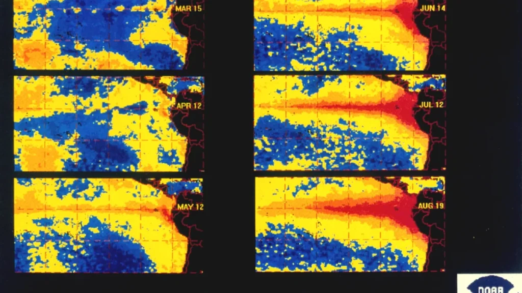
Image: NOAA, public domain, via Wikimedia Commons.
Illustrative: sea-surface temperature anomalies in the Pacific from March to August 1997, during the 1997-98 El Nino, published by NOAA. This map is from the 1997 event and is not the 2026 forecast.